AAU Herbarium Database |
| New Search Modify Search |
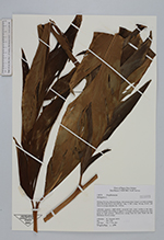
| Collector | Takeuchi, W. |
| Number | 10878 |
| Collected with | |
| Country | Papua New Guinea |
| Subpart | Madang |
| County | |
| Locality | Bismarck Range, downstream from Camp 3, on banks or slopes above thee Kalne River; Hill forest. |
| Coordinates | 5° 31.765999999999998' 144° 49.091000000000001' |
| Minimum elevation (m) | 1550 |
| Maximum elevation (m) | 1550 |
| Start date | 1995/10/17 |
| End date | 1995/10/18 |
| Family | Zingiberaceae |
| Identification | Etlingera (Blume)R.M.Sm. |
| Determined by | |
| Identification qualifier | |
| Field notes | Collection secuence 10869-10938; terrestial herb; stems swollwn at the base; leaves frondlike and arching, to approx. 5 m length, distichous, papyraceous, light green on both surfaces; inflorescence arising from the roots, bracts red and distichous; flowers orange. |
| |
| Display all 28 georeferenced records of Etlingera Etlingera |
| New Search Modify Search |