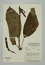
| Collector | Palacios, W. |
| Number | 8379 |
| Collected with | G.Aymard, E.Freire |
| Country | Ecuador |
| Subpart | Zamora-Chinchipe |
| County | |
| Locality | Nangaritza Cantón. Pachicutza. Camino al Hito. Cordillera del Cóndor. Bosque primario sobre pendientes de 30%. Árboles cubiertos de musgos. Suelos lentizoles. |
| Coordinates | 4° 7' S 78° 37' W |
| Minimum elevation (m) | 1000 |
| Maximum elevation (m) | 1100 |
| Start date | 1991/10/19 |
| End date | 1991/10/19 |
| Family | Araliaceae |
| Identification | Sciodaphyllum premontanum in ed. |
| Determined by | Dr. Pete Lowry |
| Identification qualifier | |
| Field notes | Arbusto hemiepífito a 1.5 m del suelo. |
|
 Other records of Sciodaphyllum premontanum