| Collector | Palacios, W. |
| Number | 1036 |
| Collected with | D. Neill, J. Zaruma |
| Country | Ecuador |
| Subpart | Napo |
| County | |
| Locality | Estación Experimental INIAP-Payamino. 5 km al norte de Coca. Bosque húmedo tropical. Suelo rojo arcilloso, collinas. Bosque primario perturbado. |
| Coordinates | 0° 26' S 77° 1' W |
| Minimum elevation (m) | 250 |
| Maximum elevation (m) | 250 |
| Start date | 1986/02/18 |
| End date | 1986/02/26 |
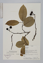
| Family | Annonaceae |
| Identification | Ruizodendron ovale (Ruiz & Pav.)R.E. Fries |
| Determined by | J.S. Oosterhof & P.J.M. Maas |
| Identification qualifier | |
| Field notes | Arbol de 15 m de altura con hojas jóvenes. Frutos verdes. |
|
 Other records of Ruizodendron ovale