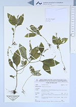
| Collector | La-ongsri, W. |
| Number | 5752 |
| Collected with | P. Panyachan, P. Tatiya, S. Satata & S. Wongwan |
| Country | Thailand |
| Subpart | Kanchanaburi |
| County | |
| Locality | Si Sawat District, Chaloem Rattanakosin National Park, Than Lod Noi cave |
| Coordinates | 14° 40' 26.19'' N 99° 17' 24.96'' E |
| Minimum elevation (m) | 623 |
| Maximum elevation (m) | 623 |
| Start date | 2018/08/21 |
| End date | 2018/08/21 |
| Family | Polygalaceae |
| Identification | Polygala umbonata Craib |
| Determined by | |
| Identification qualifier | |
| Field notes | Herb 20 cm high on limestone in mixed-deciduous forest. Flower yellow. Fruit green. |
|
 Other records of Polygala umbonata