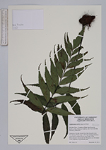
| Collector | Testo, W.L. |
| Number | 133 |
| Collected with | |
| Country | Costa Rica |
| Subpart | San Jose |
| County | |
| Locality | Cantón de Dota, San Gerardo km 80 on Pan-American Higway; km 9 on Calle San Gerardo. |
| Coordinates | |
| Minimum elevation (m) | 2300 |
| Maximum elevation (m) | 2300 |
| Start date | 2012/12/29 |
| End date | 2012/12/29 |
| Family | Aspleniaceae |
| Identification | Asplenium serra Langsd. & Fischer |
| Determined by | |
| Identification qualifier | |
| Field notes | Terrestrial. On side of trail from San Gerado to La Providencia. Plants large, with long creeping rhizomes; occasionally scandent on low tree trunks. With Monochaetum vulcanicum and Thelypteris sp. In shaded woods adjacent to agricultural field. |
|