| Collector | Eiserhardt, W.L. |
| Number | 171 |
| Collected with | W.J. Baker, D.Pedersen, Eugéne Pierre, Dina Rakotoarivelo, Rabemily |
| Country | Madagascar |
| Subpart | Alaotra-Mangoro, Moramanga |
| County | |
| Locality | Mantadia NP, Tsakoka trail |
| Coordinates | 18° 47' 45.8'' S 48° 25' 41.7'' E |
| Minimum elevation (m) | 978 |
| Maximum elevation (m) | 978 |
| Start date | 2024/05/04 |
| End date | 2024/05/04 |
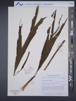
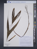
| Family | Arecaceae |
| Identification | Dypsis hildebrandtii (Baill.) Becc. |
| Determined by | W.L. Eiserhardt, W.J. Baker |
| Identification qualifier | |
| Field notes | Clustering understorey palm, stem to ca. 1.5 m, 9 leaves in crown. Inflorescence interfoliar, pendulous, branched to 2 orders. 48 cm long, thereof 22 cm rachis. Prophyll 17 cm long, persistent, bract 18 cm, both 1 cm wide. Ca. 20 first-order branches, rachillae 40-50 cm long, 1 mm wide, hairy with red, sparse tomentum. In hillside forest with grassy understorey. DNA sample at AAU. Duplicates at TAN, K |
|
 Other records of Dypsis hildebrandtii