AAU Herbarium Database |
| New Search Modify Search |
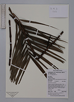
| Collector | Baker, W.J. |
| Number | 1380 |
| Collected with | L.M.Gardiner, J.Wanma and P.Bofra |
| Country | Indonesia |
| Subpart | West Papua |
| County | |
| Locality | Tambrouw Regency. Bamusbama District. Forest along road to Fef east of Bamusbama. High forest on ridge top |
| Coordinates | 0° 45' 47'' S 132° 16' '' E |
| Minimum elevation (m) | 950 |
| Maximum elevation (m) | 950 |
| Start date | 2013/01/28 |
| End date | 2013/01/28 |
| Family | Arecaceae |
| Identification | Hydriastele |
| Determined by | |
| Identification qualifier | |
| Field notes | Slender, clustering, undergrowth palm to 1.5m, clustering by short stolons. Leaves 4-5 in crown, 25-30cm long, leaflets dark glossy green, dark indumentum on leaves and sheaths. Inflorescence spicate, yellowish to green. Female flowers past anthesis, brown. |
| |
 Other records of Hydriastele Other records of HydriasteleThe map displays only records from the Aarhus Herbarium Database. The records may not represent the full distribution of Hydriastele |
| New Search Modify Search |