AAU Herbarium Database |
| New Search Modify Search |
| Collector | Baker, W. J. |
| Number | 1140 |
| Collected with | Roy Banka, Kathleen King |
| Country | Papua New Guinea |
| Subpart | Western |
| County | |
| Locality | Junction of Harvey Creek and Ok Mani River, 10km WNW of Tabubil. Valley side near river margin |
| Coordinates | 5° 14' 28.5'' S 141° 8' 22.1'' E |
| Minimum elevation (m) | 750 |
| Maximum elevation (m) | 750 |
| Start date | 2000/12/14 |
| End date | 2000/12/14 |
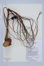
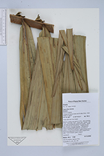
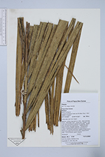
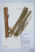
| Family | Arecaceae |
| Identification | Orania |
| Determined by | |
| Identification qualifier | |
| Field notes | Massive, solitary tree palm to c.25m. Stem diameter 27cm. Internodes 12cm. Crown with 7 leaves. Leaf c.6m long including 2m petiole and sheaths. Sheath with rust-colored indumentum. Leaflets 68 each side of rachis, arranged regularly. Inflorescence 230cm including 95cm peduncle, branched to 2 orders, c.50 primary branches, largest primary branch 80cm long, peduncle to 8.5cm wide, prophyll 25cm wide. Fruit immature, green irregular |
| |
 Other records of Orania Other records of OraniaThe map displays only records from the Aarhus Herbarium Database. The records may not represent the full distribution of Orania |
| New Search Modify Search |