| Collector | Baker, W.J. |
| Number | 1131 |
| Collected with | et al. |
| Country | Papua New Guinea |
| Subpart | Western |
| County | |
| Locality | North Fly District Road from Tabubil to Ok Tedi copper mine, 8.5km N of Tabubil, c.2km NW of Finalbin |
| Coordinates | 5° 12' 31.2'' S 141° 10' 42.4'' E |
| Minimum elevation (m) | 1000 |
| Maximum elevation (m) | 1000 |
| Start date | 2000/12/12 |
| End date | 2000/12/12 |
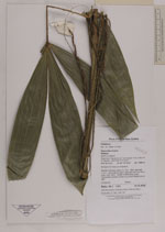
| Family | Arecaceae |
| Identification | Calamus oresbius W.J.Baker & J.Dransf. |
| Determined by | A. Henderson |
| Identification qualifier | |
| Field notes | Montane hill forest on limestone. Slender montane rattan to c.10m. Stem diameter c.1cm. Internodes to 40cm, although less than 40cm lower down stem. Sheath mottled grey-green. Transverse veinlets conspicuous when leaflet held to light |
|
 Other records of Calamus oresbius