AAU Herbarium Database |
| New Search Modify Search |
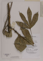
| Collector | Baker, W.J. |
| Number | 1121 |
| Collected with | |
| Country | Papua New Guinea |
| Subpart | |
| County | |
| Locality | Southern Highlands Erave District Side of road to Gobe oil rigs, 91 km NW of Kikori. Montane forest on limestone karst ridgetop, numerous cliffs and sinkholes |
| Coordinates | 6° 46' 45.7'' S 143° 43' 59'' E |
| Minimum elevation (m) | 1000 |
| Maximum elevation (m) | 1000 |
| Start date | 2000/11/27 |
| End date | 2000/11/27 |
| Family | Arecaceae |
| Identification | Calamus |
| Determined by | |
| Identification qualifier | |
| Field notes | Solitary rattan to 4m. Stem diam. with sheaths 15mm, without sheaths 10mm. Sheaths with numerous short fine spines, also covered with moss. Leaf 40cm long, no petiole. Leaflets 9 each side of rachis, lowermost pair reflexed across stem, remainder in divaricate groups of 2 |
| |
| Display all 31 georeferenced records of Calamus Calamus |
| New Search Modify Search |