AAU Herbarium Database |
| New Search Modify Search |
| Collector | Baker, W.J. |
| Number | 1101 |
| Collected with | R. Banka, K. King, O. Gebia & A. Ona |
| Country | Papua New Guinea |
| Subpart | |
| County | |
| Locality | Papua New Guinea Gulf. Kikori District. Kopi-Kikori road, 10 km NW of Kikori. Lowland swamp forest on limestone |
| Coordinates | 7° 20' 16.7'' S 144° 12' 9.4'' E |
| Minimum elevation (m) | 40 |
| Maximum elevation (m) | 40 |
| Start date | 2000/11/21 |
| End date | 2000/11/21 |
| Family | Arecaceae |
| Identification | Calyptrocalyx |
| Determined by | W.J. Baker |
| Identification qualifier | |
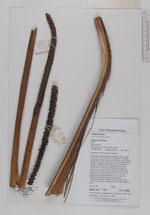
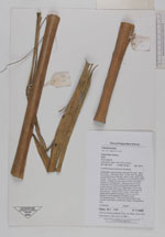
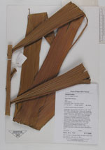
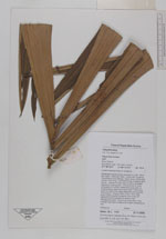
| Field notes | Moderately robust solitary tree palm to c.8m. Stem 9cm diam. Internode 16cm. Crown with 18 leaves. Crownshaft poorly defined, 150cm long x 20cm wide. Sheath 75cm long. Leaf 290cm long, including 40cm petiole. Leaflets 30 each side of rachis, arranged regularly to subregularly. Inflorescence 2m long, composed of 3 similar unbranched axes within a single prophyll, peduncle of each axis 110cm long, axes 2cm diam, with easily detached rust-coloured indumentum. Prophyll 55cm long x 10cm wide, space within prophyll divided by one or two thin partitions which separate the bases of the inflorescence axes. Peduncular bract 80cm long, inserted near base of peduncle of each inflorescence axis. |
| |
 Other records of Calyptrocalyx Other records of CalyptrocalyxThe map displays only records from the Aarhus Herbarium Database. The records may not represent the full distribution of Calyptrocalyx |
| New Search Modify Search |