AAU Herbarium Database |
| New Search Modify Search |
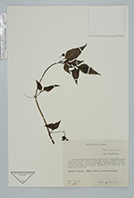
| Collector | Zak, V. |
| Number | 966 |
| Collected with | |
| Country | Ecuador |
| Subpart | Pichincha |
| County | |
| Locality | Carretera antigua Chillogallo-San Juan-Chiriboga-Empalme, km 27. Vegetación de bosque montano alto. Área lluviosa. Suelo humífero. Colecciones en borde de carretero y bosque. |
| Coordinates | 0° 17' 49'' S 78° 38' 47'' W |
| Minimum elevation (m) | 3180 |
| Maximum elevation (m) | 3180 |
| Start date | 1986/02/24 |
| End date | 1986/02/24 |
| Family | Solanaceae |
| Identification | Jaltomata |
| Determined by | Andres Orejuela |
| Identification qualifier | |
| Field notes | Arbusto de 1 m. Cáliz verde. Corola blanca. |
| |
 Other records of Jaltomata Other records of JaltomataThe map displays only records from the Aarhus Herbarium Database. The records may not represent the full distribution of Jaltomata |
| New Search Modify Search |