AAU Herbarium Database |
| New Search Modify Search |
| Collector | Zak, V. |
| Number | 4268 |
| Collected with | D.Rubio |
| Country | Ecuador |
| Subpart | Pastaza |
| County | |
| Locality | Carretera de PETRO-CANADA en construcción. Vía Auca, 115 km all Sur de Coca, 6 km al S del Río Tigüino. Bosque húmedo tropical; lomas; suelo rojo Dystropept. Árboles del bosque primario, cortados. |
| Coordinates | 1° 15' S 76° 55' W |
| Minimum elevation (m) | 320 |
| Maximum elevation (m) | 320 |
| Start date | 1989/04/01 |
| End date | 1989/04/09 |
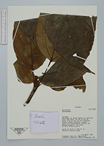
| Family | Araliaceae |
| Identification | Dendropanax Decne. & Planch. |
| Determined by | |
| Identification qualifier | |
| Field notes | Árbol de 20-25 m; DAP 25 cm. Botones florales café. |
| |
| Display all 123 georeferenced records of Dendropanax Dendropanax |
| New Search Modify Search |