AAU Herbarium Database |
| New Search Modify Search |
| Collector | Blicher-Mathiesen, U. |
| Number | 62605 |
| Collected with | Klitgaard, B. B. |
| Country | Ecuador |
| Subpart | NAPO |
| County | |
| Locality | Laguna Cuyabeno. Trail west of the laguna. Tropical rainforest. Terra firme. |
| Coordinates | 0° 5' S 76° 11' W |
| Minimum elevation (m) | 265 |
| Maximum elevation (m) | 265 |
| Start date | 1987/12/09 |
| End date | 1987/12/09 |
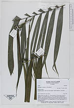
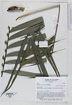
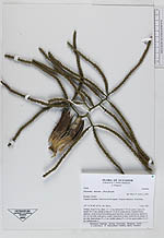
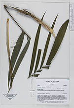
| Family | Arecaceae |
| Identification | Geonoma maxima (Poit.)Kunth |
| Determined by | Skov, F. (AAU), 1989. |
| Identification qualifier | |
| Field notes | Solitary. Stem 3,5 m, diam. 1,5 - 2 cm; internodes 1-20 cm, green. Leaves 8; sheath 30 x 2 cm, tubular at base for 15 cm in young leaves, rounded below, glabrous, cream at base becomming green upwards, creamy tomentous; petiole 21 cm, 0,3 cm wide, dark green, creamy tomentouse at base; rachis 48 cm; pinnae 16 per side, basal pinnae 27 x 3 cm, middle pinnae 27 x 2,5 cm, apical pinnae 21 x 3 cm. Inflorescence 1. |
| |
 Other records of Geonoma maxima Other records of Geonoma maximaThe map displays only records from the Aarhus Herbarium Database. The records may not represent the full distribution of Geonoma maxima |
| New Search Modify Search |