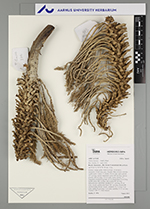
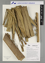
| Field notes | Solitary canopy palm. Stem 4 m high, 36 cm thick; internodes 10 cm long, gray, fissured. Base of stem with few visible roots. Leaves 15; sheath 120 cm long, open; petiole 127 cm long, section margined; rachis 600 cm long; lamina pinnate, 680 cm long, 224 cm wide, bushy; pinnae 191, irregularly inserted in groups of 3-4; basal pinna 72 cm long, middle pinna 160 cm long, apical pinna 81 cm long. Infructescence interfoliar; prophyll 37+ cm long; 30 cm wide, woody; peduncular bract 140+ cm long, inserted 80 cm from base, brown, woody; peduncle 70+ c, long, 5 cm wide; rachis 50 cm long, 5 cm wide; rachillae 13-15 cm long. Transect: HB 777, from transect |
 Other records of Attalea maripa