AAU Herbarium Database |
| New Search Modify Search |
| Collector | Emilio, T. |
| Number | 872 |
| Collected with | |
| Country | Brazil |
| Subpart | Amazonas |
| County | |
| Locality | Río Juruá. Comunidado Deixa Falar. Primary forest on terrace |
| Coordinates | 6° 39' 26.6'' S 70° 12' 32.7'' W |
| Minimum elevation (m) | 154 |
| Maximum elevation (m) | 154 |
| Start date | 2012/05/04 |
| End date | 2012/05/04 |
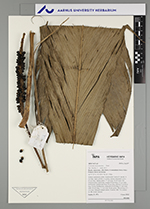
| Family | Arecaceae |
| Identification | Geonoma macrostachys Mart. |
| Determined by | T. Emilio |
| Identification qualifier | |
| Field notes | Solitary understory palm. Acaulescent. Leaves 9; sheath 14 cm long, open; petiole 4 cm long, section margined; rachis 62 cm long; lamina entire, 77 cm long, 24 cm wide, flat. Infructescence interfoliar; prophyll 8 cm long, 1.5 cm wide, herbaceous; peduncular bract 30 cm long, inserted 7 cm from base, brown, herbaceous; peduncle 64 cm long, 0.7 cm wide; spike 30 cm long, 1.2 cm wide. Fruits green, 0.8 cm long, 0.7 cm wide. Silicagel sample taken. Transect: HB 776, subunit no. 88, inside transect |
| |
| Display all 92 georeferenced records of Geonoma Geonoma macrostachys |
| New Search Modify Search |