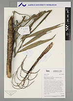
| Field notes | Colonial palm. Liana. Leaves numerous; sheath 14 cm long, closed, with 2 cm long black spines; petiole 3 cm long, section margined, with 0.8 cm long black spines; rachis 131 cm long, with 15 cm long black spines; cirrhus 67 cm long; lamina pinnate, 153 cm long, 49 cm wide, flat; pinnae 28 per side, insertion regular; basal pinna 29 cm long, middle pinna 22 cm long, apical pinna 21 cm long. Infructescence interfoliar; prophyll 28 cm long, 2.5 cm wide, herbaceous; peduncular bract 43 cm long, inserted 12 cm from base, brown, herbaceous, with 1 cm long black spines; peduncle 19 cm long, 1.2 cm wide; rachis 15 cm long, 0.8 cm wide, with 0.9 cm long black spines; rachillae 22, 4-9 cm long. Fruits red, 1.6 cm long, 1.2 cm wide. Silicagel sample taken. Transect: HB 774, outside transect |
 Other records of Desmoncus