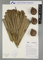
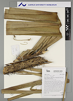
| Field notes | Solitary canopy palm. Stem 30 m high, 25 cm thick; internodes 10 cm long, brown, fissured. Leaves 7; sheath 274 cm long, with 12 cm long yellow spines; petiole 31 cm long, section round, with 7 cm long yellow spines; rachis 470 cm long, with 10 cm long yellow spines; lamina pinnate, 507 cm long, 256 cm wide, bushy, glabrous; pinnae 147 per side, basal pinna 88 cm long, middle pinna 120 cm long, apical pinna 30 cm long. Infructescence interfoliar; prophyll 102 cm long, 16 cm wide, herbaceous, with 0.3 cm long brown spines; peduncle 97 cm long, 8 cm wide, with 4.5 cm long brown spines; rachillae 175, 4-14 cm long. Fruits green, 9 cm long, 6 cm wide, spinulose. Silicagel sample taken. Transect: HB 773, subunit no. 82, inside transect |
 Other records of Astrocaryum chambira