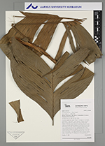
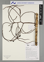
| Field notes | Cespitose understory palm. Stem 1-2 m high, 2-3 cm thick; internodes 1.5 cm long, < stem diameter, reddish, smooth. Base of stem with few visible roots. Leaves 8 per stem; sheath 13 cm long, open; petiole 45 cm long, section round; rachis 46 cm long; lamina pinnate, 59 cm long, 42 cm wide, flat; pinnae 3 per side, insertion irregular; basal pinna 8 cm long, middle pinna 34 cm long, apical pinna 28 cm long. Infructescence infrafoliar, peduncle 10 cm long, 1 cm wide; rachis 6 cm long, 0.5 cm wide; rachillae 4-7 cm, 17-23 cm long. Fruits green, 1 cm long, 0.8 cm wide. Silicagel sample taken. Transect: HB 772, subunit no. 26, inside transect |