AAU Herbarium Database |
| New Search Modify Search |
| Collector | Emilio, T. |
| Number | 860 |
| Collected with | |
| Country | Brazil |
| Subpart | Amazonas |
| County | |
| Locality | Río Juruá. Comunidado Caxinauó. Primary forest on terrace |
| Coordinates | 6° 46' 31.6'' S 70° 7' .8'' W |
| Minimum elevation (m) | 128 |
| Maximum elevation (m) | 128 |
| Start date | 2012/04/30 |
| End date | 2012/04/30 |
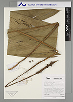
| Family | Arecaceae |
| Identification | Geonoma macrostachys Mart. |
| Determined by | T. Emilio |
| Identification qualifier | |
| Field notes | Solitary understory palm. Acaulescent. Leaves 11-12; sheath 18 cm long, open; petiole 5 cm long, section more or less round; rachis 82 cm long; lamina entire, 103 cm long, 24 cm wide. Infructescence interfoliar; peduncle 66+ cm long, 0.6 cm wide; spike 15 cm long, 1.2 cm wide. Fruits green, 0.7 cm long, 0.8 cm wide Transect: HB 772, to transect |
| |
| Display all 92 georeferenced records of Geonoma Geonoma macrostachys |
| New Search Modify Search |