AAU Herbarium Database |
| New Search Modify Search |
| Collector | Emilio, T. |
| Number | 857 |
| Collected with | H. Balslev & D. Pedersen |
| Country | Brazil |
| Subpart | Amazonas |
| County | |
| Locality | Río Juruá. 361 km SW of Carauari. 24 km NE of Eirunepé. 2 km NE of Nova Morada W. Primary forest on terra firme |
| Coordinates | 6° 32' 15.8'' S 69° 41' 53.4'' W |
| Minimum elevation (m) | 158 |
| Maximum elevation (m) | 158 |
| Start date | 2012/04/25 |
| End date | 2012/04/25 |
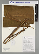
| Family | Arecaceae |
| Identification | Geonoma macrostachys var. macrostachys Mart. |
| Determined by | H.Balslev & T. Emilio |
| Identification qualifier | |
| Field notes | Solitary understory palm. Acaulescent; internodes < 1 cm, < stem diameter, rough. Base with few visible roots. Leaves 11; sheath 13 cm long, open; petiole 4 cm long, section margined; rachis 68 cm long; lamina entire, 99 cm long, 26 cm wide, flat, glabrous. Infructescence interfoliar; prophyll 15 cm long, 1.5 cm wide; peduncular bract 35 cm long, inserted 6 cm from base, brown, herbaceous; peduncle 63 cm long, 0.5 cm wide; spike 23 cm long, 1 cm wide. Fruits green, 0.7 cm long, 0.6 cm wide. Silicagel sample taken. Transect: HB 770, subunit no. 56, outside transect |
| |
| Display all 220 georeferenced records of Geonoma Geonoma macrostachys var. macrostachys |
| New Search Modify Search |