AAU Herbarium Database |
| New Search Modify Search |
| Collector | Emilio, T. |
| Number | 849 |
| Collected with | H. Balslev & D. Pedersen |
| Country | Brazil |
| Subpart | Amazonas |
| County | |
| Locality | Río Juruá. 348 km SW of Carauari. 36 km NE of Eirunepé. 2.5 km NE of Remazo. Primary forest on terra firme |
| Coordinates | 6° 30' 51.2'' S 69° 34' 42.6'' W |
| Minimum elevation (m) | 139 |
| Maximum elevation (m) | 139 |
| Start date | 2012/04/23 |
| End date | 2012/04/23 |
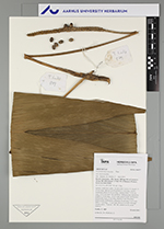
| Family | Arecaceae |
| Identification | Geonoma macrostachys var. macrostachys Mart. |
| Determined by | H.Balslev & T. Emilio |
| Identification qualifier | |
| Field notes | Solitary understory palm. Acaulescent. Leaves 15, sheath 11-15 cm long, open to closed; petiole 2-3 cm long, section margined; rachis 53-62 cm long; lamina entire, 77-92 cm long, 19-21 cm wide, flat, glabrous. Inflorescence interfoliar; prophyll 10 cm long, 1.2 cm wide, green/cream, herbaceous; peduncular bract 25 cm long, inserted 1 cm from base, green/cream, herbaceous; peduncle 56 cm long, 5 cm wide; spike 17 cm long, 1.2 cm wide. Flowers in buds. Silicagel sample taken. Transect: HB 768, subunit no. 8, inside transect |
| |
| Display all 220 georeferenced records of Geonoma Geonoma macrostachys var. macrostachys |
| New Search Modify Search |