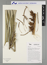
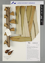
| Field notes | Solitary midstory palm. Stem 8 m high, 20 cm thick; internodes 2-10 cm long, brown, smooth. Base of stem with few visible roots. Leaves 15; sheath 3 m long, open, with 10 cm long black spines; rachis 6.5 cm long, with to 5 cm long black spines; lamina pinnate, 7 m long, 3 m wide, flat, glabrous; pinnae 112 per side, regularly inserted; basal pinna 85 cm long, middle pinna 155 cm long, apical pinna 45 cm long. Infructescence interfoliar; prophyll 50 cm long, 15 cm wide, brown, woody; peduncular bract 97 cm long, inserted 75 cm from base, brown, woody, with to 1 cm long brown spines; peduncle 105 cm long, 4 cm wide, with few to 1 cm long black spines; rachis 47 cm long, 3 cm wide; rachillae ca. 300, 25-30 cm long. Fruits orange, 7x4 cm, incl. old style; young fruits light green, spinulose. Silicagel sample taken. Transect: HB 767, subunit no. 98, outside transect |
 Other records of Astrocaryum