AAU Herbarium Database |
| New Search Modify Search |
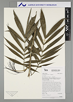
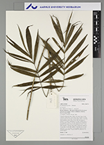
| Collector | Emilio, T. |
| Number | 846 |
| Collected with | H. Balslev & D. Pedersen |
| Country | Brazil |
| Subpart | Amazonas |
| County | |
| Locality | Río Juruá. 350 km SW of Carauari. 34 km E of Eirunepé. 1.8 km N of Remazo. Primary forest on terra firme |
| Coordinates | 6° 30' 33.4'' S 69° 36' 1.5'' W |
| Minimum elevation (m) | 159 |
| Maximum elevation (m) | 159 |
| Start date | 2012/04/22 |
| End date | 2012/04/22 |
| Family | Arecaceae |
| Identification | Wendlandiella gracilis var. gracilis Dammer |
| Determined by | H.Balslev & T. Emilio |
| Identification qualifier | |
| Field notes | Colonial understory palm. Stem 0.4 m high: Base of stem with few visible roots. Leaves 8 per stem; sheath 6 cm long, closed; petiole 11 cm long, section round; rachis 15 cm long; lamina pinnate, 28 cm long, 24 cm wide, flat, glabrous; pinnae 5-7 per side; basal pinna 9 cm long, middle pinna 15 cm long, apical pinna 14 cm long. Inflorescence interfoliar; prophyll 6 cm long, 0.8 cm wide; peduncular bract 7.5 cm long, inserted 7 cm from base, green, herbaceous; peduncle 11 cm long, 0.3 cm wide; rachis 2.5 cm long, 0.2 cm wide; rachillae 13, 4-7 cm long. Flowers cream to green, sessile. Silicagel sample taken. Transect: HB 767, subunit no. 52, inside transect |
| |
 Other records of Wendlandiella gracilis var. gracilis Other records of Wendlandiella gracilis var. gracilisThe map displays only records from the Aarhus Herbarium Database. The records may not represent the full distribution of Wendlandiella gracilis var. gracilis |
| New Search Modify Search |