AAU Herbarium Database |
| New Search Modify Search |
| Collector | Emilio, T. |
| Number | 835 |
| Collected with | H. Balslev & D. Pedersen |
| Country | Brazil |
| Subpart | Amazonas |
| County | |
| Locality | Río Juruá. 275 km SW of Carauari. 118 km E of Eirunepé. 8.3 km N of Gaviazinha. Primary forest on terra firme |
| Coordinates | 6° 27' 1.2'' S 68° 49' 18.3'' W |
| Minimum elevation (m) | 152 |
| Maximum elevation (m) | 152 |
| Start date | 2012/04/18 |
| End date | 2012/04/18 |
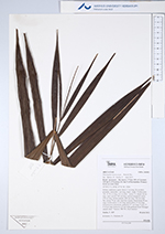
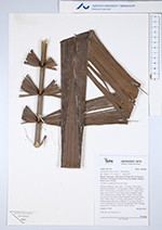
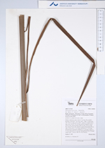
| Family | Arecaceae |
| Identification | Phytelephas macrocarpa Ruiz & Pav. |
| Determined by | H.Balslev & T. Emilio |
| Identification qualifier | |
| Field notes | Solitary understory palm. Stem 1.5 m long, 30 cm thick, prostrate; internodes 1 cm long, black, rough. Visible roots 100, 10-30 cm long, 0.4 cm thick. Leaves 14; sheath 30 cm long, open; petiole 150 cm long, section margined; rachis 578 cm long; lamina pinnate, 600 cm long, 140 cm wide, flat; pinnae 78 per side, insertion regular; basal pinna 40 cm long, middle pinna 72 cm long, apical pinna 15 cm long. Infructescence interfoliar, peduncle 15+ cm long. Fruits 17, 5-10 cm long, borne in a 25 cm wide globular head. Silicagel sample taken. Transect: HB 763, from transect |
| |
 Other records of Phytelephas macrocarpa Other records of Phytelephas macrocarpaThe map displays only records from the Aarhus Herbarium Database. The records may not represent the full distribution of Phytelephas macrocarpa |
| New Search Modify Search |