AAU Herbarium Database |
| New Search Modify Search |
| Collector | Emilio, T. |
| Number | 828 |
| Collected with | H. Balslev & D. Pedersen |
| Country | Brazil |
| Subpart | Amazonas |
| County | |
| Locality | Río Juruá. 269 km SW of Carauari. 126 km E of Eirunepé. 1.5 km N of Barro Vermelho. Primary forest on terra firme |
| Coordinates | 6° 26' 50.6'' S 68° 44' 54.4'' W |
| Minimum elevation (m) | 166 |
| Maximum elevation (m) | 166 |
| Start date | 2012/04/17 |
| End date | 2012/04/17 |
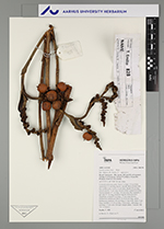
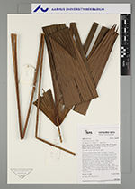
| Family | Arecaceae |
| Identification | Lepidocaryum tenue Mart. |
| Determined by | H.Balslev & T. Emilio |
| Identification qualifier | |
| Field notes | Colonial understory palm. Stem 2 m high, 2.5 cm thick; internodes 5-6 cm long, brown, smooth. Base of stem with few visible roots. Leaves 12 per stem; sheath 20 cm long, closed; petiole 75 cm long, section round, margined at base; lamina palmate, 67 cm long, 110 cm wide, flat; segments 2 per side, 67 cm long, insertion regular. Infructescence interfoliar; prophyll 9 cm long, 1.7 cm wide, brown, herbaceous; peduncular bracts 10, 8-10 cm long, green, herbaceous; peduncle 105 cm long, 0.7 cm wide; rachis 5 cm long; rachillae 2, 9-20 cm long. Fruits scaly, red/orange, 2.5 cm long, 1.7 cm wide. Silicagel sample taken. Transect: HB 762, to transect |
| |
 Other records of Lepidocaryum tenue Other records of Lepidocaryum tenueThe map displays only records from the Aarhus Herbarium Database. The records may not represent the full distribution of Lepidocaryum tenue |
| New Search Modify Search |