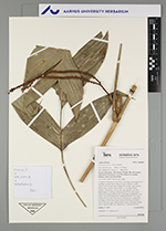
| Field notes | Cespitose understory palm. Stem 1.8 m high; internodes 8-10 cm long, smooth, brown. Base of stem with few visible roots. Leaves 14 per stem; sheath 10 cm long, open; petiole 18 cm long, section round; rachis 31 cm long; lamina pinnate, 38 cm long, 36 cm wide, flat; pinnae 3 per side; basal pinna 22 cm long, middle pinna 20 cm long, apical pinna 18 cm long. Inflorescence interfoliar; prophyll 5.5 cm long, 1 cm wide, herbaceous; peduncular bract 5 cm long, inserted 0.5 cm from base, brown, herbaceous; peduncle 8 cm long, 0.4 cm wide, green; rachis 0 cm long, rachillae 2, 19-21 cm long, green. Flower buds sunken. Silicagel sample taken. Transect: HB 761, subunit no. 1, outside transect |