AAU Herbarium Database |
| New Search Modify Search |
| Collector | Emilio, T. |
| Number | 818 |
| Collected with | H. Balslev & D. Pedersen |
| Country | Brazil |
| Subpart | Amazonas |
| County | |
| Locality | Río Juruá. 260 km SW of Carauari. 137 km E of Eirunepé. 2.3 km N of Cubiu. Primary forest on terra firme |
| Coordinates | 6° 26' 32.1'' S 68° 38' 50.1'' W |
| Minimum elevation (m) | 159 |
| Maximum elevation (m) | 159 |
| Start date | 2012/04/15 |
| End date | 2012/04/15 |
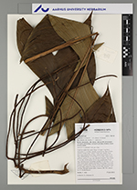
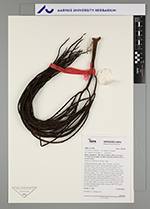
| Family | Arecaceae |
| Identification | Geonoma occidentalis (A.J.Hend.)A.J.Hend. |
| Determined by | H.Balslev & T. Emilio |
| Identification qualifier | |
| Field notes | Cespitose understory palm. Stem 2 m high, 2 cm thick; internodes 2-3 cm long, smooth, green/brown. Base of stem with few visible roots. Leaves 15 per stem; sheath 10 cm long, open; petiole 60 cm long, section round; rachis 47 cm long; lamina pinnate, 55 cm long, 32 cm wide, a little bushy, glabrous; pinnae 5-6 per side, insertion irregular; basal pinna 22 cm long, middle pinna 26 cm long, apical pinna 24 cm long. Infructescence infrafoliar; prophyll 10 cm long, 3.5 cm wide, brown/green; peduncular bract 10 cm long, 4 cm wide, inserted 1 cm from base, brown, woody; peduncle 8 cm long, 0.7 cm wide; rachis 2 cm long, 0.5 cm wide; rachillae 7, 4-7 cm long. Silicagel sample taken. Transect: HB 760, subunit no. 54, inside transect |
| |
 Other records of Geonoma occidentalis Other records of Geonoma occidentalisThe map displays only records from the Aarhus Herbarium Database. The records may not represent the full distribution of Geonoma occidentalis |
| New Search Modify Search |