AAU Herbarium Database |
| New Search Modify Search |
| Collector | Emilio, T. |
| Number | 800 |
| Collected with | H. Balslev & D. Pedersen |
| Country | Brazil |
| Subpart | Amazonas |
| County | |
| Locality | Río Juruá. 225 km SW of Carauari. 6.8 km N of Itamarati. Primary forest on terra firme |
| Coordinates | 6° 22' 58.7'' S 68° 15' 45'' W |
| Minimum elevation (m) | 207 |
| Maximum elevation (m) | 207 |
| Start date | 2012/04/10 |
| End date | 2012/04/10 |
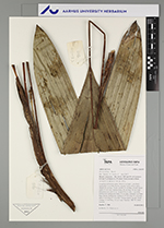
| Family | Arecaceae |
| Identification | Bactris killipii Burret |
| Determined by | H.Balslev & T. Emilio |
| Identification qualifier | |
| Field notes | Cespitose understory palm. Stem 0.3 m high, 1 cm thick; internodes 3 cm long, brown, smooth. Leaves 8 per stem; sheath 10 cm long, closed; petiole 35 cm long, section round; rachis 15 cm long; lamina entire, 50 cm long, 16 cm wide. Infructescence interfoliar; prophyll 8 cm long, 1 cm wide, herbaceous; peduncular bract 15 cm long, inserted 5 cm from base, brown, herbaceous; peduncle 15 cm long, 0.2 cm wide; spike 5 cm long, 0.5 cm wide. Flowers green, sessile. Fruits orange, 1.5 cm long, 1.2 cm wide. Transect: HB 755, from transect |
| |
 Other records of Bactris killipii Other records of Bactris killipiiThe map displays only records from the Aarhus Herbarium Database. The records may not represent the full distribution of Bactris killipii |
| New Search Modify Search |