AAU Herbarium Database |
| New Search Modify Search |
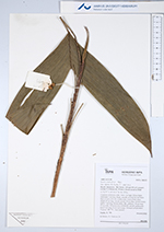
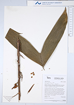
| Collector | Emilio, T. |
| Number | 799 |
| Collected with | H. Balslev & D. Pedersen |
| Country | Brazil |
| Subpart | Amazonas |
| County | |
| Locality | Río Juruá. 225 km SW of Carauari. 6.8 km N of Itamarati. Primary forest on terra firme |
| Coordinates | 6° 22' 58.7'' S 68° 15' 45'' W |
| Minimum elevation (m) | 207 |
| Maximum elevation (m) | 207 |
| Start date | 2012/04/10 |
| End date | 2012/04/10 |
| Family | Arecaceae |
| Identification | Bactris simplicifrons Mart. |
| Determined by | H.Balslev & T. Emilio |
| Identification qualifier | |
| Field notes | Cespitose understory palm. Stem 1 m high, 0.8 cm thick; internodes 4 cm long, black, smooth, covered by leaf bases. Base of stem with few visible roots. Leaves 8 per stem; sheath 10 cm long, closed; petiole 20 cm long, section round; rachis 7 cm long; lamina entire, flat, glabrous, 30 cm long, 22 cm wide. Infructescence infrafoliar, spicate; peduncular bract 5 cm long. Fruits red/orange. Silicagel sample taken. Transect: HB 755 , from transect |

| |
| Display all 89 georeferenced records of Bactris Bactris simplicifrons |
| New Search Modify Search |