AAU Herbarium Database |
| New Search Modify Search |
| Collector | Emilio, T. |
| Number | 795 |
| Collected with | H. Balslev & D. Pedersen |
| Country | Brazil |
| Subpart | Amazonas |
| County | |
| Locality | Río Juruá. 225 km SW of Carauari. 6.8 km N of Itamarati. Primary forest on terra firme |
| Coordinates | 6° 22' 52.9'' S 68° 15' 51.3'' W |
| Minimum elevation (m) | 160 |
| Maximum elevation (m) | 160 |
| Start date | 2012/04/10 |
| End date | 2012/04/10 |
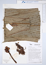
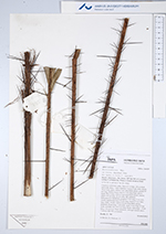
| Family | Arecaceae |
| Identification | Bactris acanthocarpa var. trailliana (Barb.Rodr.)A.J.Hend. |
| Determined by | H.Balslev & T. Emilio |
| Identification qualifier | |
| Field notes | Cespitose understory palm. Stem 0.2 m high, 2.8 cm thick; internodes short, < stem diameter. Leaves 9 per stem; sheath 30 cm long, open, with to 7 cm long black spines; petiole 95 cm long, section round, with to 7 cm long black spines; rachis 78 cm long, with to 5 cm long black spines; lamina entire 120 cm long, 35 cm wide, flat, glabrous. Infructescence interfoliar: prophyll 5 cm long, 3 cm wide, woody; peduncular bract 25 cm long, inserted 3 cm from base, black, woody, with to 0.8 cm long black spines; peduncle 10 cm long, 1 cm wide; rachis 3 cm long, 0.5 cm wide; rachillae 5-6, 2-5.5 cm long. Fruits red/orange, 1.8 cm long, 1.8 cm wide, black spinulose. Silicagel sample taken. Transect: HB 755, to transect |

| |
 Other records of Bactris acanthocarpa var. trailliana Other records of Bactris acanthocarpa var. traillianaThe map displays only records from the Aarhus Herbarium Database. The records may not represent the full distribution of Bactris acanthocarpa var. trailliana |
| New Search Modify Search |