AAU Herbarium Database |
| New Search Modify Search |
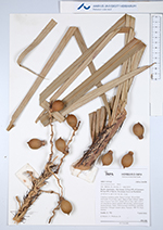
| Collector | Emilio, T. |
| Number | 792 |
| Collected with | H. Balslev & D. Pedersen |
| Country | Brazil |
| Subpart | Amazonas |
| County | |
| Locality | Río Juruá. 213 km SW of Carauari. 0.5 km SW of Quirio. Seconsary forest on floodplain |
| Coordinates | 6° 17' 7.5'' S 68° 13' 10.2'' W |
| Minimum elevation (m) | 112 |
| Maximum elevation (m) | 112 |
| Start date | 2012/04/07 |
| End date | 2012/04/07 |
| Family | Arecaceae |
| Identification | Astrocaryum jauari Mart. |
| Determined by | H.Balslev & T. Emilio |
| Identification qualifier | |
| Field notes | Cespitose midstory palm. Stem 4 m high, 18 cm thick; internodes 30 cm long, spiny. Base of stem without visible roots. Leaves 7 per stem; sheath 0.8 cm long, open, with 3 cm long brown spines; petiole 100 cm long, section round; lamina pinnate, bushy. Infructescence interfoliar; rachillae numerous. Silicagel sample taken. Transect: HB 753, from transect |

| |
 Other records of Astrocaryum jauari Other records of Astrocaryum jauariThe map displays only records from the Aarhus Herbarium Database. The records may not represent the full distribution of Astrocaryum jauari |
| New Search Modify Search |