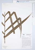
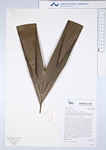
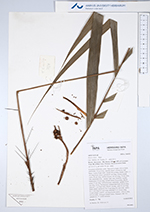
| Field notes | Cespitose understory palm. Stem 0.5 m high, 0.8 cm thick; internodes 5-6 cm long, smooth, black, covered by leaf bases. Leaves 8 per stem; sheath 20 cm long, closed, with 1.5 cm long black spines; petiole 62 cm long, section round; rachis 36 cm long; lamina pinnate, 65 cm long, 70 cm wide, flat, underside hairy; pinnae 5 per side, insertion regular; basal pinna 32 cm long, middle pinna 34 cm long, apical pinna 37 cm long. Infructescence interfoliar; prophyll 6-9 cm long, brown, herbaceous; peduncular bract 20 cm long, inserted 1 cm from base, brown, woody, with 0.5 cm long black spines; peduncle 10-13 cm long, 0.5 cm wide; rachis 0.5-1 cm long, 0.3 cm wide; rachillae 3, 2.5-6 cm long. Fruits orange, with 0.1 cm long brown spines , 0.8 cm long, 0.9 cm wide, Silicagel sample taken. Transect: HB 752, subunit no. 37, inside transect |

 Other records of Bactris hirta var. spruceana