AAU Herbarium Database |
| New Search Modify Search |
| Collector | Emilio, T. |
| Number | 781 |
| Collected with | H. Balslev & D. Pedersen |
| Country | Brazil |
| Subpart | Amazonas |
| County | |
| Locality | Río Juruá. 205 km SW of Carauari. 0.5 km N of Dona Nene. Primary riverside vegetation on floodplain. Growing in clumps in 1 m deep water along crek in rainforest |
| Coordinates | 6° 14' 41.8'' S 68° 8' 40.4'' W |
| Minimum elevation (m) | 105 |
| Maximum elevation (m) | 105 |
| Start date | 2012/04/05 |
| End date | 2012/04/05 |
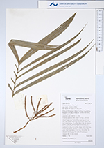
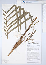
| Family | Arecaceae |
| Identification | Geonoma maxima subsp. compta (Trail) A.J.Hend. |
| Determined by | |
| Identification qualifier | |
| Field notes | Cespitose understory palm. Stem 2-3 m high, 1 cm thick; internodes 2-5 cm long, grey-green, smooth. Base of stem without visible roots. Leaves 6-7 per stem; sheath 12 cm long, open; petiole 55 cm long, section round; rachis 47 cm long; lamina pinnate, 75 cm long, 60 cm wide, flat, glabrous; pinnae 15 per side, insertion regular; middle pinna 38 cm long, apical pinna 27 cm long. Infructescence infrafoliar; peduncle 8 cm long, 0.8 cm wide, orange; rachis 10 cm long, 0.5 cm wide, orange; rachillae 11, 11-20 cm long. Fruits green, black when mature, 0.9 cm long, 0.8 cm wide. The specimen measured was large, other specimens in the population about half the size. Silicagel sample taken. Transect: HB 751, from transect |


| |
 Other records of Geonoma maxima subsp. compta Other records of Geonoma maxima subsp. comptaThe map displays only records from the Aarhus Herbarium Database. The records may not represent the full distribution of Geonoma maxima subsp. compta |
| New Search Modify Search |