AAU Herbarium Database |
| New Search Modify Search |
| Collector | Emilio, T. |
| Number | 780 |
| Collected with | H. Balslev & D. Pedersen |
| Country | Brazil |
| Subpart | Amazonas |
| County | |
| Locality | Río Juruá. 205 km SW of Carauari. 0.5 km N of Dona Nene. Primary riverside vegetation on floodplain. Growing in deep warter along a creek |
| Coordinates | 6° 14' 33.7'' S 68° 8' 39.8'' W |
| Minimum elevation (m) | 107 |
| Maximum elevation (m) | 107 |
| Start date | 2012/04/05 |
| End date | 2012/04/05 |
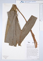
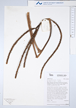
| Family | Arecaceae |
| Identification | Geonoma umbraculiformis Wess.Boer |
| Determined by | H.Balslev & T. Emilio |
| Identification qualifier | ? |
| Field notes | Colonial understory palm. Stem 1.5 m high, 1.5 cm thick; internodes 5-10 cm long, brown, smooth. Leaves 5-6 per stem; sheath 15 cm long, closed; petiole 13 cm long, section margined; rachis 43 cm long; lamina pinnate, 70 cm long, 30 cm wide, flat, glabrous; pinnae 3-4 per side, irregularly inserted; basal pinna 40 cm long, middle pinna 40 cm long, apical pinna 35 cm long. Infructescence interfoliar; prophyll 32 cm long, 2 cm wide, herbaceous to woody, furrowed; peduncular bract 33 cm long, inserted 5 cm from base, brown, papery; peduncle 43 cm long, 1 cm wide, orange; rachis 8 cm long, 1 cm wide; rachillae 6, 15-30 cm long. Fruits green to black, 1.5 cm long, 1 cm wide. Silicagel sample taken. Transect: HB 751, from transect |

| |
 Other records of Geonoma umbraculiformis Other records of Geonoma umbraculiformisThe map displays only records from the Aarhus Herbarium Database. The records may not represent the full distribution of Geonoma umbraculiformis |
| New Search Modify Search |