AAU Herbarium Database |
| New Search Modify Search |
| Collector | Emilio, T. |
| Number | 777 |
| Collected with | H. Balslev & D. Pedersen |
| Country | Brazil |
| Subpart | Amazonas |
| County | |
| Locality | Río Juruá. 205 km SW of Carauari. 1.2 km N of Dona Nene. Primary forest on terra firme |
| Coordinates | 6° 14' 10.5'' S 68° 8' 51.7'' W |
| Minimum elevation (m) | 152 |
| Maximum elevation (m) | 152 |
| Start date | 2012/04/05 |
| End date | 2012/04/05 |
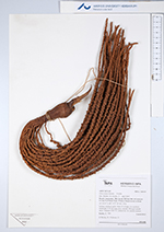
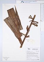
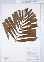
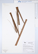
| Family | Arecaceae |
| Identification | Oenocarpus balickii F. Kahn |
| Determined by | H.Balslev & T. Emilio |
| Identification qualifier | |
| Field notes | Solitary midstory palm. Stem 10 m high, 5-6 cm thick; internodes 5-15 cm long, grey, smooth. Silicagel sample taken. Transect: HB 751, subunit no. 16, outside transect |
| |
 Other records of Oenocarpus balickii Other records of Oenocarpus balickiiThe map displays only records from the Aarhus Herbarium Database. The records may not represent the full distribution of Oenocarpus balickii |
| New Search Modify Search |