AAU Herbarium Database |
| New Search Modify Search |
| Collector | Emilio, T. |
| Number | 775 |
| Collected with | H. Balslev & D. Pedersen |
| Country | Brazil |
| Subpart | Amazonas |
| County | |
| Locality | Río Juruá. 205 km SW of Carauari. 1.2 km N of Dona Nene. Primary forest on terra firme |
| Coordinates | 6° 14' 11.6'' S 68° 8' 51.4'' W |
| Minimum elevation (m) | 153 |
| Maximum elevation (m) | 153 |
| Start date | 2012/04/05 |
| End date | 2012/04/05 |
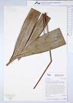
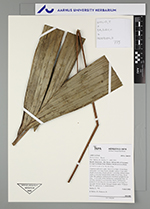
| Family | Arecaceae |
| Identification | Bactris killipii Burret |
| Determined by | H.Balslev & T. Emilio |
| Identification qualifier | "2" |
| Field notes | Cespitose understory palm. Stem 0.3 m high, 0.8 cm thick; internodes 3 cm long, brown, smooth. Leaves 15 per stem; sheath 16 cm long, closed; petiole 75 cm long, section round; rachis 13 cm long; lamina entire, bifid, 45 cm long, 26 cm wide, flat, glabrous. Inflorescence interfoliar; prophyll 6 cm long, 1.1 cm wide, white, herbaceous; peduncular bract 16 cm long, inserted 13 cm from base, brown, herbaceous; peduncle 23 cm long, 0.6 cm wide; spike 5.5 cm long, 0.5 cm wide. Flowers sessile. Silicagel sample taken. Transect: HB 751, subunit no. 9, inside transect |
| |
 Other records of Bactris killipii Other records of Bactris killipiiThe map displays only records from the Aarhus Herbarium Database. The records may not represent the full distribution of Bactris killipii |
| New Search Modify Search |