AAU Herbarium Database |
| New Search Modify Search |
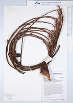
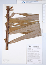
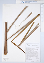
| Collector | Emilio, T. |
| Number | 774 |
| Collected with | H. Balslev & D. Pedersen |
| Country | Brazil |
| Subpart | Amazonas |
| County | |
| Locality | Río Juruá. 175 km SW of Carauari. 9.5 km W of Boca Xurua. Primary forest on terrace |
| Coordinates | 6° 3' 16.8'' S 67° 54' 35.6'' W |
| Minimum elevation (m) | 118 |
| Maximum elevation (m) | 118 |
| Start date | 2012/04/04 |
| End date | 2012/04/04 |
| Family | Arecaceae |
| Identification | Oenocarpus minor Mart. |
| Determined by | H.Balslev & T. Emilio |
| Identification qualifier | |
| Field notes | Cespitose midstory palm. Stem 6 m high, 6 cm thick; internodes 15-20 cm long, brown, fissured. Base of stem with root cone. Crownshaft 60 cm long. Leaves 7; sheath 65 cm long, closed; petiole 50 cm long, section margined; rachis 380 cm long; lamina pinnate, 400 cm long, 180 cm wide, flat, glabrous; pinnae 49 per side, insertion regular; basal pinna 90 cm long, middle pinna 85 cm long, apical pinna 20 cm long. Inflorescence infrafoliar; peduncular bract inserted 5 cm from base; peduncle 7 cm long, 2.5 cm wide, rachis 18 cm long, 1-2.5 cm wide; rachillae 65, 60 cm long. Flowers sessile. Silicagel sample taken. Transect: HB 750, subunit no. 100, outside transect |
| |
 Other records of Oenocarpus minor Other records of Oenocarpus minorThe map displays only records from the Aarhus Herbarium Database. The records may not represent the full distribution of Oenocarpus minor |
| New Search Modify Search |