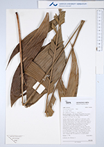
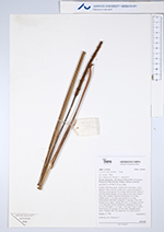
| Field notes | Solitary understory palm. Acaulescent. Internodes < stem diameter. Base with few visible roots. Leaves 8; sheath 15 cm long, closed; petiole 75 cm long, section round; rachis 57 cm long; lamina pinnate; 76 cm long, 64 cm wide; pinnae 5-9 per side, insertion irregular; basal pinna 33 cm long, middle pinna 32 cm long, apical pinna 25 cm long. Inflorescence interfoliar; prophyll 5.5 cm long, 1 cm wide, herbaceous to papery; peduncular bract 17 cm long, inserted 1 cm from base, brown, herbaceous; peduncle 87 cm long, 0.5 cm wide; spike 17 cm long, 1 cm wide. Flowers sunken. Fruits green, 0.5 cm long, 0.5 cm wide. Silicagel sample taken. Transect: HB 750, subunit no. 16, inside transect |