AAU Herbarium Database |
| New Search Modify Search |
| Collector | Emilio, T. |
| Number | 770 |
| Collected with | H. Balslev & D. Pedersen |
| Country | Brazil |
| Subpart | Amazonas |
| County | |
| Locality | Río Juruá. 172 km SW of Carauari. 9.5 km W of Boca Xurua. Primary forest on terrace |
| Coordinates | 6° 3' 32.7'' S 67° 54' 33.1'' W |
| Minimum elevation (m) | 101 |
| Maximum elevation (m) | 101 |
| Start date | 2012/04/04 |
| End date | 2012/04/04 |
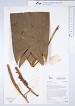
| Family | Arecaceae |
| Identification | Geonoma stricta var. stricta (Poit.)Kunth |
| Determined by | H.Balslev & T. Emilio |
| Identification qualifier | |
| Field notes | Cespitose understory palm. Stem 1.8 m high. Leaves 10 per stem; sheath 10 cm long, closed; petiole 10 cm long, section margined; rachis 47 cm long; lamina entire, 51 cm long, 18 cm wide, flat, glabrous. Inflorescence interfoliar; prophyll 3.5-5 cm long, 1 cm wide, herbaceous; peduncular bract missing; peduncle 3 cm long, 0.8 cm wide; spike 7-9 cm long, 1 cm wide. Flowers sunken. Silicagel sample taken. Transect: HB 750, subunit no. 2, inside transect |
| |
| Display all 90 georeferenced records of Geonoma Geonoma stricta var. stricta |
| New Search Modify Search |