AAU Herbarium Database |
| New Search Modify Search |
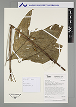
| Collector | Emilio, T. |
| Number | 769 |
| Collected with | H. Balslev & D. Pedersen |
| Country | Brazil |
| Subpart | Amazonas |
| County | |
| Locality | Río Juruá. 155 km SW of Carauari. 2.3 km SW of Xibahua. Primary forest on terrace |
| Coordinates | 5° 52' 43.8'' S 67° 52' 23.3'' W |
| Minimum elevation (m) | 122 |
| Maximum elevation (m) | 122 |
| Start date | 2012/04/03 |
| End date | 2012/04/03 |
| Family | Arecaceae |
| Identification | Bactris simplicifrons Mart. |
| Determined by | H.Balslev & T. Emilio |
| Identification qualifier | |
| Field notes | Solitary understory palm. Stem 1 m high, 0.5 cm thick; internodes 3-4 cm long, green, covered by leaf bases. Leaves 6 per stem; sheath 8.5 cm long, closed; petiole 16 cm long, section round; rachis 16 cm long; lamina entire, 28 cm long, 17 cm wide, flat, glabrous. Infructescence infrafoliar; prophyll 1.5 cm long, 0.4 cm wide, herbaceous; peduncle 3.5 cm long, 0.3 cm wide, spike 2.5 cm long. Fruits orange, 0.7 cm long, 0.6 cm wide. Silicagel sample taken. Transect: HB 749, subunit no. 48, inside transect |
| |
| Display all 89 georeferenced records of Bactris Bactris simplicifrons |
| New Search Modify Search |