AAU Herbarium Database |
| New Search Modify Search |
| Collector | Emilio, T. |
| Number | 767 |
| Collected with | H. Balslev & D. Pedersen |
| Country | Brazil |
| Subpart | Amazonas |
| County | |
| Locality | Río Juruá. 151 km SW of Carauari. 0.3 km NW of Xibahua. Primary forest on floodplain. |
| Coordinates | 5° 53' 30.7'' S 67° 51' 39.7'' W |
| Minimum elevation (m) | 105 |
| Maximum elevation (m) | 105 |
| Start date | 2012/04/02 |
| End date | 2012/04/02 |
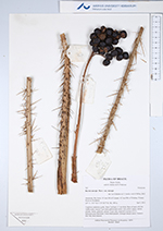
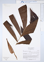
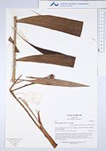
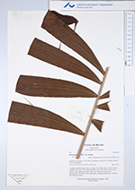
| Family | Arecaceae |
| Identification | Bactris maraja var. maraja Mart. |
| Determined by | H.Balslev & T. Emilio |
| Identification qualifier | |
| Field notes | Cespitose understory palm. Stem 2 m high, 1.5 cm thick. Base of stem with few visible roots. Leaves 7 per stem; petiole and rachis with yellow spines; lamina pinnate, bushy, glabrous; pinnae 14 per side, inserted in groups of 2-3. Infructescence interfoliar. Fruits black/purple. Silicagel sample taken. Transect: HB 748, from transect |
| |
| Display all 55 georeferenced records of Bactris Bactris maraja var. maraja |
| New Search Modify Search |