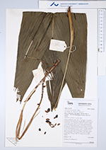
| Field notes | Solitary understory palm. Stem 1.3 cm high, 1.5 cm thick; internodes 10 cm long, green, smooth. Base of stem with 25 visible roots, 5-25 cm long, 0.3 cm thick. Leaves 5; sheath 25 cm long, closed; petiole 10 cm long, section margined; rachis 42 cm long; lamina entire, 77 cm long, 27 cm wide, flat, glabrous. Infructescence interfoliar; prophyll 3 cm long, 0.7 cm wide, peduncular bracts 3, 10-15 cm long, inserted 4, 10 and 19 cm from base, brown, papery; peduncle 33 cm long, 0.4 cm wide; spike 37 cm long, 0.4 cm wide, orange. Fruits green/black, 1.2 cm long, 0.7 cm wide. Silicagel sample taken. Transect: HB 747, subunit no. 56, inside transect |