AAU Herbarium Database |
| New Search Modify Search |
| Collector | Emilio, T. |
| Number | 744 |
| Collected with | H. Balslev & D. Pedersen |
| Country | Brazil |
| Subpart | Amazonas |
| County | |
| Locality | Río Juruá. 67 km SW of Carauari. 3.6 km SE of Bom Jesus. Primary forest on terra firme |
| Coordinates | 5° 24' 23.4'' S 67° 11' 57.8'' W |
| Minimum elevation (m) | 119 |
| Maximum elevation (m) | 119 |
| Start date | 2012/03/30 |
| End date | 2012/03/30 |
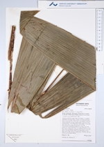
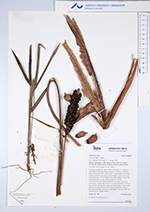
| Family | Arecaceae |
| Identification | Bactris killipii Burret |
| Determined by | H.Balslev & T. Emilio |
| Identification qualifier | |
| Field notes | Cespitose understory palm. Stem 0.5 m high, 1.1 cm thick; internodes 6 cm long, black, smooth, covered by leaf bases. Base of stem with few visible roots. Leaf sheath 25 cm long, closed; petiole 85 cm long, section round; rachis 4 cm long; lamina pinnate, 55 cm long, 60 cm wide; pinnae 1-2 per side; basal pinna 58 cm long, apical pinna 65 cm long. Infructescence interfoliar; prophyll 9 cm long, 1 cm wide, herbaceous; peduncular bract 25 cm long, inserted 6 cm from base, brown, herbaceous; peduncle 20 cm long, 0.5 cm wide; spike 5 cm long, 0.8 cm wide. Fruits white/green, 0.9 cm long, 0.8 cm wide. Silicagel sample taken. Transect: HB 744, subunit no. 64, inside transect |
| |
 Other records of Bactris killipii Other records of Bactris killipiiThe map displays only records from the Aarhus Herbarium Database. The records may not represent the full distribution of Bactris killipii |
| New Search Modify Search |