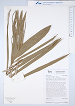
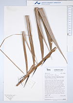
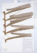
| Field notes | Cespitose understory palm. Stem 4.5 m high, 2.8 cm thick; internodes 5 cm long, grey, smooth, with 8 cm long spines. Base of stem without visible roots. Leaves 11 per stem; sheath 20 cm long, open, with 3 cm long black spines; petiole 65 cm long, section round, with 10 cm long black spines; rachis 170 cm long, with 3-8 cm long black spines; lamina pinnate, 190 cm long, 110 cm wide, flat, glabrous; pinnae 35 per side, insertion regular, basal pinna 48 cm long, middle pinna 58 cm long, apical pinna 23 cm long. Infructescence interfoliar; prophyll 45 cm long, 3.5 cm wide, herbaceous; peduncular bract 37 cm long, inserted 30 cm from base, brown, thin, woody; peduncle 50-70 cm long, 0.5-1 cm wide, with 1.5 cm long black/brown spines; rachis 10-17 cm long, rachillae numerous. Fruits 2.5 cm long, 1.7 cm wide. Silicagel sample taken. Transect: HB 744, subunit no. 1, outside transect |
 Other records of Astrocaryum gynacanthum