AAU Herbarium Database |
| New Search Modify Search |
| Collector | Emilio, T. |
| Number | 738 |
| Collected with | H. Balslev & D. Pedersen |
| Country | Brazil |
| Subpart | Amazonas |
| County | |
| Locality | Río Juruá. 67.5 km SW of Carauari. 3.6 km SE of Bom Jesus. Primary forest on terra firme |
| Coordinates | 5° 24' 22.5'' S 67° 12' 8.9'' W |
| Minimum elevation (m) | 101 |
| Maximum elevation (m) | 101 |
| Start date | 2012/03/30 |
| End date | 2012/03/30 |
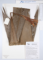
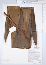
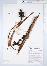
| Family | Arecaceae |
| Identification | Geonoma oldemanii de Granville |
| Determined by | H.Balslev & T. Emilio |
| Identification qualifier | ? |
| Field notes | Cespitose understory palm. Stem 4.5 m high, 2-2.5 cm thick; internodes 8 cm long, light brown, smooth. Base of stem without visible roots. Leaves 13, sheath 14 cm long, open; petiole 10 cm long, section margined; rachis 76 cm long; lamina entire, 107 cm long, 19 cm wide, flat. Infructescence: prophyll 20 cm long, 2.5 cm wide, papery; peduncular bract 60 cm long, inserted 1 cm from base, brown, papery; peduncle 45 cm long, 0.9 cm wide, spike orange. Fruits green, 1.9 cm long, 1.7 cm wide. Silicagel sample taken. Transect: HB 744, subunit no. 1, outside transect |
| |
 Other records of Geonoma oldemanii Other records of Geonoma oldemaniiThe map displays only records from the Aarhus Herbarium Database. The records may not represent the full distribution of Geonoma oldemanii |
| New Search Modify Search |