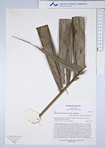
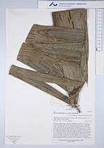
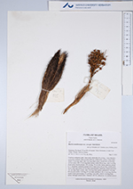
| Field notes | Cespitose understory palm. Stem areal; internodes 20 cm long, < stem diameter, covered by leafbases. Base of stem with few visible roots. Leaves 7-9 per stem; sheath 15 cm long, open, with 3 cm long black spines; petiole 60-120 cm long, section round, with 4-5 cm long black spines; rachis 98 cm long, with 3 cm long black spines; lamina pinnate, 120 cm long, 70 cm wide, bushy, glabrous; pinnae 9-11, irregularly inserted in groups of 2-3; basal pinna 40 cm long, middle pinna 50 cm long, apical pinna 50 cm long. Infructescence interfoliar; peduncular bract 16+ cm long, black, woody, with 1 cm long black spines; peduncle 5+ cm long, 0.8 cm wide; rachis 2 cm long, 0.5 cm wide; rachillae 6-18, 1-2 cm long. Flowers sessile. Fruits green/orange, 2.3 cm long, 2 cm wide, with 0.3 cm long black spines. Silicagel sample taken. Transect: HB 741, subunit no. 10, outside transect |
 Other records of Bactris acanthocarpa var. exscapa