AAU Herbarium Database |
| New Search Modify Search |
| Collector | Emilio, T. |
| Number | 707 |
| Collected with | H. Balslev & D. Pedersen |
| Country | Brazil |
| Subpart | Amazonas |
| County | |
| Locality | Río Juruá, 6.5 km NW of Carauari. Primary forest on terra firme |
| Coordinates | 4° 54' 17.7'' S 66° 56' 52.2'' W |
| Minimum elevation (m) | 110 |
| Maximum elevation (m) | 110 |
| Start date | 2012/03/24 |
| End date | 2012/03/24 |
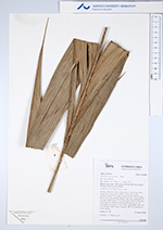
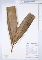
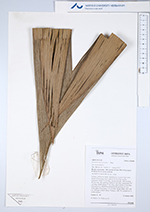
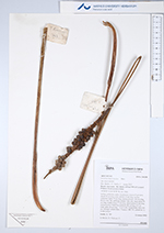
| Family | Arecaceae |
| Identification | Geonoma macrostachys var. macrostachys Mart. |
| Determined by | H.Balslev & T. Emilio |
| Identification qualifier | |
| Field notes | Solitary understory palm. Acaulescent. Leaves 9 per stem; sheath 20 cm long, open; petiole 35 cm long, section margined; rachis 75 cm long; lamina pinnate, 100 cm long, 40 cm wide, flat, glabrous; pinnae 3 per side; basal pinna 50 cm long, middle pinna 57 cm long, apical pinna 53 cm long. Infructescence interfoliar; peduncle 80 cm long, 0.7 cm wide; spike 20 cm long, 1.4 cm wide. Fruits black, 0.8 x 0.8 cm. Silicagel sample taken. Transect: HB 739, subunit no. 4, inside transect |
| |
| Display all 220 georeferenced records of Geonoma Geonoma macrostachys var. macrostachys |
| New Search Modify Search |