AAU Herbarium Database |
| New Search Modify Search |
| Collector | Emilio, T. |
| Number | 703 |
| Collected with | H. Balslev & D. Pedersen |
| Country | Brazil |
| Subpart | Amazonas |
| County | |
| Locality | Río Juruá, 9.6 km N of Carauari. Primary forest on terra firme |
| Coordinates | 4° 47' 50.4'' S 66° 52' 11.2'' W |
| Minimum elevation (m) | 107 |
| Maximum elevation (m) | 107 |
| Start date | 2012/03/23 |
| End date | 2012/03/23 |
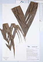
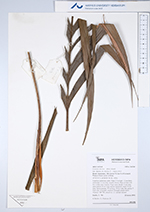
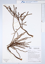
| Family | Arecaceae |
| Identification | Geonoma deversa (Poit.)Kunth |
| Determined by | H.Balslev & T. Emilio |
| Identification qualifier | |
| Field notes | Cespitose understory palm. Stem 2.3 m high, 1.5 cm thick; internodes 3-4 cm long, smooth, brown. Base of stem with few visible roots. Leaves 10 per stem; sheath 15 cm long, open; petiole 20 cm long, section margined; rachis 55 cm long; lamina pinnate, 70 cm long, 30 cm wide, flat; pinnae 7-9 per side, irregularly inserted. Silicagel sample taken. Transect: HB 738, subunit no. 21, outside transect |
| |
| Display all 104 georeferenced records of Geonoma Geonoma deversa |
| New Search Modify Search |