AAU Herbarium Database |
| New Search Modify Search |
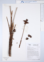
| Collector | Emilio, T. |
| Number | 702 |
| Collected with | H. Balslev & D. Pedersen |
| Country | Brazil |
| Subpart | Amazonas |
| County | |
| Locality | Río Juruá, 9.6 km N of Carauari. Primary forest on terra firme |
| Coordinates | 4° 47' 49.7'' S 66° 52' 10.4'' W |
| Minimum elevation (m) | 106 |
| Maximum elevation (m) | 106 |
| Start date | 2012/03/23 |
| End date | 2012/03/23 |
| Family | Arecaceae |
| Identification | Bactris oligocarpa Barb.Rodr. |
| Determined by | H.Balslev & T. Emilio |
| Identification qualifier | |
| Field notes | Cespitose understory palm. Stem 0.3 m high, 1 cm thick. Base of stem with few visible roots. Leaves 11 per stem; sheath 10 cm long, open, with 3 cm long black spines; petiole 80 cm long, section round; rachis 27 cm long; lamina pinnate, 55 cm long, 60 cm wide, flat, glabrous; pinnae 2-3 per side, insertion regular; basal pinna 39 cm long, apical pinna 41 cm long. Infrutescence infrafoliar; peduncle 18 cm long, 0.6 cm wide; rachis 3 cm long. Fruits 1.8 cm long, 1.3 cm wide, black. Silicagel sample taken. Transect: HB 738, subunit no. 16, inside transect |

| |
 Other records of Bactris oligocarpa Other records of Bactris oligocarpaThe map displays only records from the Aarhus Herbarium Database. The records may not represent the full distribution of Bactris oligocarpa |
| New Search Modify Search |